Welcome
My name is Jie Chen (陈杰). I’m now an associate professor at School of Oceanography, Shanghai Jiao Tong University. Before that, I was a postdoc at Laboratoire de Géologie, Ecole Normale Supérieure (ENS), PSL University as a part of MUSH-OCEAN ANR project (2024-2025) and Marine Geosciences, Institut de Physique du Globe de Paris (IPGP), Universitè Paris Cité (2022-2024).
I use geomorphological (bathymetry, sidescan, and seafloor imagery), geophysical (gravity, magnetic, and seismicity) and numerical approaches to investigating seafloor spreading processes at the mid-ocean ridges. Recently, I focus on submarine mass wasting using high-resolution bathymetry collected by Autonomous Underwater Vehicle (AUV) and magma convection of fast-spreading ridges using numerical modelling.
Our group is looking for excellent postdocs/students. Please contact me If you are interested in subjects below or beyond: Recruitment.pdf
欢迎对以下方向感兴趣的博士后、博士生、硕士生加入课题组! 欢迎邮件联系! 招聘信息
Email: chenjie.geo@sjtu.edu.cn / chenjie.geo@outlook.com
See more in Bilibili, Google Scholar, ResearchGate, ORCID
- Mid-Ocean Ridges
- Autonomous Underwater Vehicle
- Geological mapping
- Submarine volcanism
- Submarine mass wasting
- Oceanic detachment fault
- Numerical modelling
- Hydrothermal system
- Seismicity
Ph.D., Marine Geosciences, 2018.10-2021.12
Universitè Paris Cité, IPGP
M. E., Marine Geophysics, 2015.09-2018.06
Second Institute of Oceanography, MNR
B. E., Geophysics, 2011.08-2015.06
Ocean University of China
Publications
as of 2026-01
Research Projects
Looking into the Earth from multiple perspectives
Seafloor Mapping
For work and for fun
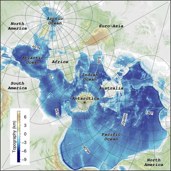
Spilhaus World Ocean Map
See more maps: Chen et al., (2023): Ocean Sciences with the Spilhaus Projection: A Seamless Ocean Map for Spatial Data Recognition. Scientific Data. https://doi.org/10.1038/s41597-023-02309-6 Chen, Jie (2022): Spilhaus World Ocean Map.

Bathymetry map showing slow and ultraslow spreading ridges
Chen, Jie (2022): Bathymetry map showing slow and ultraslow spreading ridges. figshare. Figure. https://doi.org/10.6084/m9.figshare.19561030.v1 Figure design inspiration comes from Bing Dwen Dwen (Beijing 2022 Olympic Mascot).
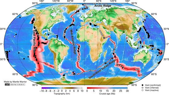
Global distribution of hydrothermal vents with respect to spreading rate
Chen, Jie (2021): Global distribution of hydrothermal vents with respect to spreading rate. figshare. Figure. https://doi.org/10.6084/m9.figshare.17357678.v2 Datasets are from multiple sources: topography (Weatherall et al., 2015), crustal age (Seton et al.
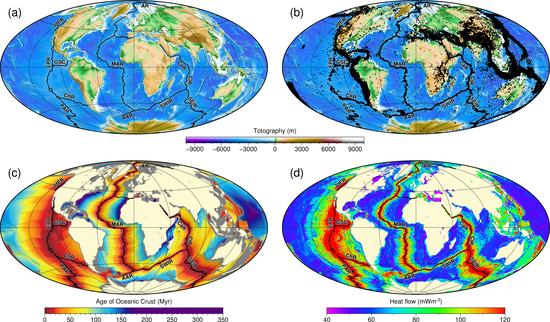
The global Mid-Ocean Ridge system
Chen, Jie (2021): The global Mid-Ocean Ridge system. figshare. Figure. https://doi.org/10.6084/m9.figshare.16628449.v1 (a) Topography, (b) teleseismic earthquakes (Mb>4), (c) age of oceanic crust, and (d) heat flow. Datasets are from multiple sources: topography (Weatherall et al.
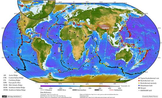
Bathymetry map of the global Mid-Ocean Ridges
Chen, Jie (2021): Bathymetry map showing global Mid-Ocean Ridge, hydrothermal vent fields, and detachment faults. figshare. Figure. https://doi.org/10.6084/m9.figshare.14680419.v2
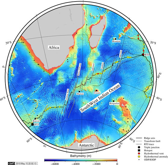
Bathymetry map of the Southwest Indian Ridge
Chen, Jie (2021): Bathymetry map of the Southwest Indian Ridge. figshare. Figure. https://doi.org/10.6084/m9.figshare.14933397.v2
Multiple styles of bathymetry maps showing the Mid-Ocean Ridges
Chen, Jie (2021): Seafloor mapping: multiple styles of bathymetry maps showing the Mid-Ocean Ridges. figshare. Figure. https://doi.org/10.6084/m9.figshare.16529472.v1
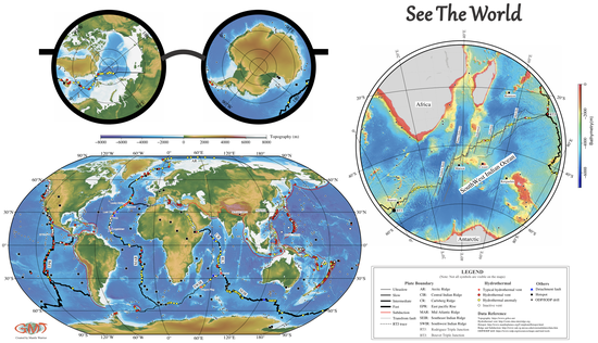
See The World
Chen, Jie (2021): Global bathymetry map: See The World. figshare. Figure. https://doi.org/10.6084/m9.figshare.14933442.v2